FATHOM’S DRONE MAG SURVEY NEATLY CORRELATES RESULTS OF THE SUMMER SOIL GEOCHEMISTRY PROGRAM AT GOCHAGER LAKE PROJECT
Drone MAG survey highlights include:
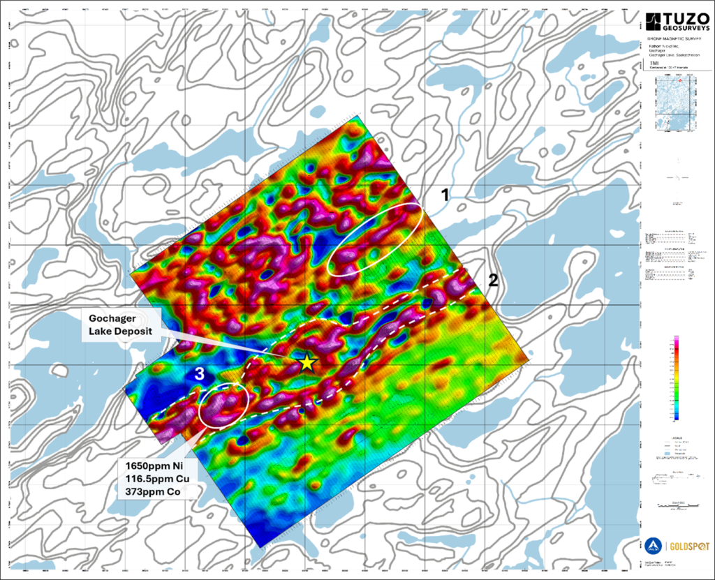
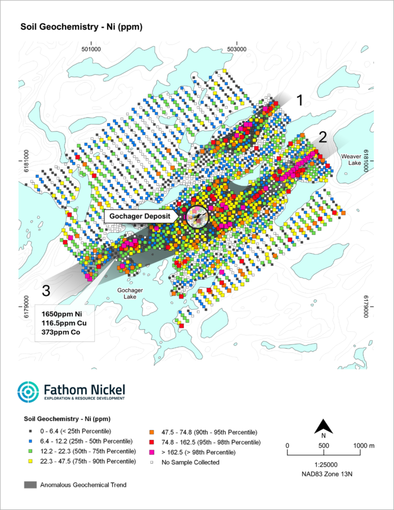
- Multiple and significant magnetic (MAG) anomalies neatly correlate with numerous multi-element (Ni-Cu-Co-Cr±Mg) anomalies defined by the recently completed soil geochemistry program (Figures 1 & 2).
- Areas of higher MAG intensity, directly associated with Ni-Cu-Co-Cr±Mg in soil anomalies, are further evidence of both extensions of known mafic to ultramafic rock in the subsurface at the Gochager Lake Property, as well as newly discovered mafic/ultramafic occurrences.
- MAG results further highlight priority areas that will be the subject of ground follow-up and surface geophysical surveys ahead of drill testing.
NOT FOR DISTRIBUTION TO UNITED STATES NEWSWIRE SERVICES OR FOR DISSEMINATION IN THE UNITED STATES. ANY FAILURE TO COMPLY WITH THIS RESTRICTION MAY CONSTITUTE A VIOLATION OF U.S. SECURITIES LAWS
Calgary, Alberta – October 3, 2024 – Fathom Nickel Inc. (the “Company” or “Fathom”) (CSE:FNI) (FSE: 6Q5), (OTCQB: FNICF) is pleased to announce the results from an unmanned aerial vehicle (“UAV” or drone) high-resolution geophysical (MAG) survey performed at the Company’s 100% owned Gochager Lake Property.
Fathom contracted TUZO GeoSurveys Corp. to perform the drone MAG survey. The survey was flown from August 7 to 10, 2024, resulting in 367.2 line-kilometers flown. Data acquisition was conducted with traverse lines flown at an azimuth of 145° with 30 meter spacing, and tie lines flown at an azimuth of 055° with 300 meter spacing. In all, the survey area covered 9.58 km2 and was flown directly over the area covered by soil geochemistry in June 2024. The results of this survey confirm that UAV is a very cost-efficient means of collecting high-resolution magnetic data and has contributed significantly to Fathom’s understanding of the dynamic, historic Gochager Lake deposit and surrounding area.
Ian Fraser, CEO and VP Exploration stated, “We are very pleased with the results of the drone MAG survey and look forward to additional surveys of this type as we continue to explore the Gochager Lake Property. The detail from this survey provides a clearer perspective than the historic 2008 VTEM data from which we have been working with to date. This new MAG data, along with results of the summer soil geochemistry and mapping / prospecting results, is further confirmation that the “container” rock that hosts the Gochager Lake deposit, is very much open along strike. The MAG survey also further reveals the structural complexity of the deposit area. We were very intrigued to see the “eye-like” signal within our expanded footprint and the excellent correlation between MAG and soil geochem results. The eye-like feature is possibly mapping a dilatant zone within a broad regional feature we interpret to be the possible magma conduit of the Gochager Lake deposit. The survey area has not closed off these encouraging trends. Like the soil geochemistry results, expansion of the MAG survey is required along strike. Detailed MAG, soil geochemistry and surface EM surveys are proving to be very successful as we continue to build an inventory of high priority drill targets at the Gocher Lake Property.”
Figure 1 – Drone MAG Total Magnetic Intensity (TMI) Map

- The Gochager Lake Deposit – occurs and is associated with a MAG high that intensifies in strength to the W-SW and NE.
- The white dash line – outlines an apparent zone of dilation; an “eye-like” feature indicative of dilation or opening along NE-SW trending structure. Area of dilation corresponds with Anomalous Geochemical Trend (Figure 2).
- Area 1 – Strong NE-SW trending linear MAG corresponds directly with Ni-Cu-Co-Cr-Mg in soil anomaly (Figure 2) indicative of possible Gochager-like mafic-ultramafic rock subsurface.
- Area 2 – Strong linear MAG feature corresponds directly with well developed very linear, 500+m strong Ni-Cu-Co-Cr-Mg in soil anomaly (Figure 2). MAG indicative of possible Gochager-like, mafic-ultramafic rock subsurface. Linear geometry in MAG and soil suggests a possible dyke of mafic-ultramafic composition.
- Area 3 – Strong MAG corresponding directly with area of highest Ni (1650ppm) in soil.
Figure 2 – Ni in Soil Map

- Area 1 direct coincident Ni in soil with MAG (Figure 1).
- Anomalous Geochemical Trend (grey shade) coincident with interpreted dilation zone (Figure 1).
- Area 2 – 500+m Ni in soil anomaly, linear and directly coincident with MAG (Figure 1).
- Area 3 – Highest Ni in soil directly coincident with MAG (Figure 1).
Completion of Second Year Anniversary Payment of Gochager Lake Earn-In Agreement
Fathom is also pleased to report that both the cash payment and share issuance for the second-year anniversary of the Gochager Lake Earn-In Agreement (the “Agreement”) has now been completed. Under the terms of the Agreement, Fathom was required to make a cash payment of $30,000 and issue 250,000 shares in order to complete the Second Anniversary requirements. However, at the request of the vendor, the terms of the Second Anniversary requirements were amended to reduce the cash payment to $22,500 and increase the share issuance to 500,000 (the original 250,000 shares and additional 250,000 shares valued at $0.03 per share).
Commenting on the Agreement, Doug Porter, President and CFO stated, “We were pleased when the Gochager Lake vendor approached us and requested an amendment to the Agreement to weigh more heavily towards the share issuance. This clearly demonstrates the vendor’s continued belief in the potential of the Gochager Lake Property. With the required exploration spend of $2 million on qualifying exploration expenditures now also completed, we only have the final cash payment of $40,000 and the final issuance of 350,000 shares (required by September 16, 2025) in order to complete the earn-in of 100% of the Gochager Lake Project1.”
1– Subject to a 2% Net Smelter Return (“NSR”) Royalty. The NSR can be bought down to 1% based on a payment of $1,000,000 at Fathom’s option.
Quality Assurance / Quality Control (QA/QC) Disclosure Statement
Strict quality control protocols were established and adhered to during the survey. These protocols were presented within a Logistics Report that was part of final deliverables to Fathom from TUZO GeoSurveys Corp. ALS GoldSpot Discoveries Ltd. vetted and processed the high-resolution drone magnetic survey data.
Qualified Person and Data Verification
Ian Fraser, P.Geo., CEO, VP Exploration and a Director of the Company and the “qualified person” as such term is defined by National Instrument 43-101, has verified the data disclosed in this news release, and has otherwise reviewed and approved the technical information in this news release on behalf of the Company.
About Fathom Nickel Inc.
Fathom is an exploration company that is targeting magmatic nickel sulphide discoveries to support the rapidly growing global electric vehicle market and to secure the supply of North American Critical Minerals.
The Company now has a portfolio of three high-quality exploration projects located in the prolific Trans Hudson Corridor in Saskatchewan: 1) the Albert Lake Project, a 90,000+ hectare project that was host to the historic and past producing Rottenstone Mine2 (produced 28,724 tons @3.3% Ni, 1.8% Cu, 9.63 g/t 3E (Pd-Pt+Au) 1965-1969), and 2) the 22,000+ hectare Gochager Lake Project that is host to a historic, NI43-101 non-compliant open pit resource consisting of 4.3M tons at 0.295% Ni and 0.081% Cu3, and 3) the 10,000+ hectare Friesen Lake Project located 40km southwest of the historic Rottenstone Mine and 30km northwest of the historic Gochager Lake deposit.
2 – The Saskatchewan Mineral Deposit Index (SMDI #0958) reports the production grades noted above from a small open pit. Fathom cannot confirm the production numbers nor a historic resource estimate that may have been in place ahead of production. The historic pit exists, and the Company trusts the production, as noted in SMDI #0958, to be accurate. The Company has performed test assaying of Rottenstone-type mineralization and results are consistent with production grades.
3 – The Saskatchewan Mineral Deposit Index (SMDI #0880) reports drill indicated reserves at the historic Gochager Lake Deposit of 4,262,400 tons grading 0.295% Ni and 0.081% Cu mineable by open pit. Fathom cannot confirm the resource estimate, nor the parameters and methods used to prepare the reserve estimate. The estimate is not considered NI43-101 compliant and further work is required to verify this historical drill indicated reserve.
ON BEHALF OF THE BOARD
Ian Fraser, CEO & Vice President Exploration
1-403-650-9760
Email: [email protected]
or
Matthew Mickleborough, Investor Relations
1-306-531-3644
Email: [email protected]
Forward Looking Statements:
This news release contains “forward-looking statements” that are based on expectations, estimates, projections and interpretations as at the date of this news release. Forward-looking statements are frequently characterized by words such as “plan”, “expect”, “project”, “seek”, “intend”, “believe”, “anticipate”, “estimate”, “suggest”, “indicate” and other similar words or statements that certain events or conditions “may” or “will” occur, and include, without limitation, statements regarding payment of terms under the Option Agreement, permitting for the Property, receipt of an exploration permit, timing of the exploration program on the Property and the Company achieving the earn-in thresholds under the Option Agreement. Forward-looking statements relate to information that is based on assumptions of management, forecasts of future results, and estimates of amounts not yet determinable. Any statements that express predictions, expectations, beliefs, plans, projections, objectives, assumptions or future events or performance are not statements of historical fact and may be “forward-looking statements.” Forward-looking statements are subject to a variety of risks and uncertainties which could cause actual events or results to differ from those reflected in the forward-looking statements, including, without limitation: risks related to failure to obtain adequate financing on a timely basis and on acceptable terms; risks related to the outcome of legal proceedings; political and regulatory risks associated with mining and exploration; risks related to the maintenance of stock exchange listings; risks related to environmental regulation and liability; the potential for delays in exploration or development activities or the completion of feasibility studies; the uncertainty of profitability; risks and uncertainties relating to the interpretation of drill results, the geology, grade and continuity of mineral deposits; risks related to the inherent uncertainty of production and cost estimates and the potential for unexpected costs and expenses; results of prefeasibility and feasibility studies, and the possibility that future exploration, development or mining results will not be consistent with the Company’s expectations; risks related to commodity price fluctuations; and other risks and uncertainties related to the Company’s prospects, properties and business detailed elsewhere in the Company’s disclosure record. Such forward looking statements involve known and unknown risks, uncertainties and other factors which may cause the actual results, performance or achievements of the Company to be materially different from any future results, performance or achievements expressed or implied by such forward-looking statements. These forward-looking statements are made as of the date hereof and the Company does not assume any obligation to update or revise them to reflect new events or circumstances except in accordance with applicable securities laws. Actual events or results could differ materially from the Company’s expectations or projections.

